
Chapter: Ecology and the Biosphere
Ecology is the study of how organisms interact with one another and with their physical environment. Ecologists study life across several levels of biological organization, from individual organisms to the entire biosphere. At the smallest ecological scale, ecologists may study how one organism survives heat, drought, predators, or competition. At broader scales, they may study how populations grow, how species interact in communities, how energy and nutrients move through ecosystems, or how climate patterns shape entire biomes. Ecology is important because no organism lives in isolation. Every species is affected by physical conditions such as temperature, water, sunlight, soil, and salinity, as well as biological interactions such as predation, competition, disease, mutualism, and decomposition. The largest ecological system is the biosphere, which includes all regions of Earth where life exists, including land, water, the atmosphere near Earth’s surface, and the deep ocean. Ecology helps explain where organisms live, why biomes occur where they do, and how living systems respond to environmental change.

Figure 1. Ecology and the Biosphere. Ecology studies how organisms interact with one another and with their physical environment. The biosphere includes all regions of Earth where life exists, from land and water to the lower atmosphere and deep ocean.
Fields of Ecology
Ecology can be studied at several levels of organization. Organismal ecology focuses on individual organisms and how their adaptations help them survive and reproduce. Behavioral ecology focuses on how behavior affects survival and reproduction. Population ecology studies groups of individuals of the same species and how their numbers change over time. Community ecology studies interactions among populations of different species living in the same area. Ecosystem ecology studies how organisms interact with the nonliving environment through energy flow and nutrient cycling. At the broadest scale, biome ecology and global ecology examine large patterns across regions, continents, oceans, and the biosphere. These fields overlap, but each asks a different kind of question. For example, an organismal ecologist might ask how a cactus survives drought, a population ecologist might ask how fast a cactus population is growing, a community ecologist might ask which animals pollinate cactus flowers, and an ecosystem ecologist might ask how carbon and water move through a desert ecosystem.
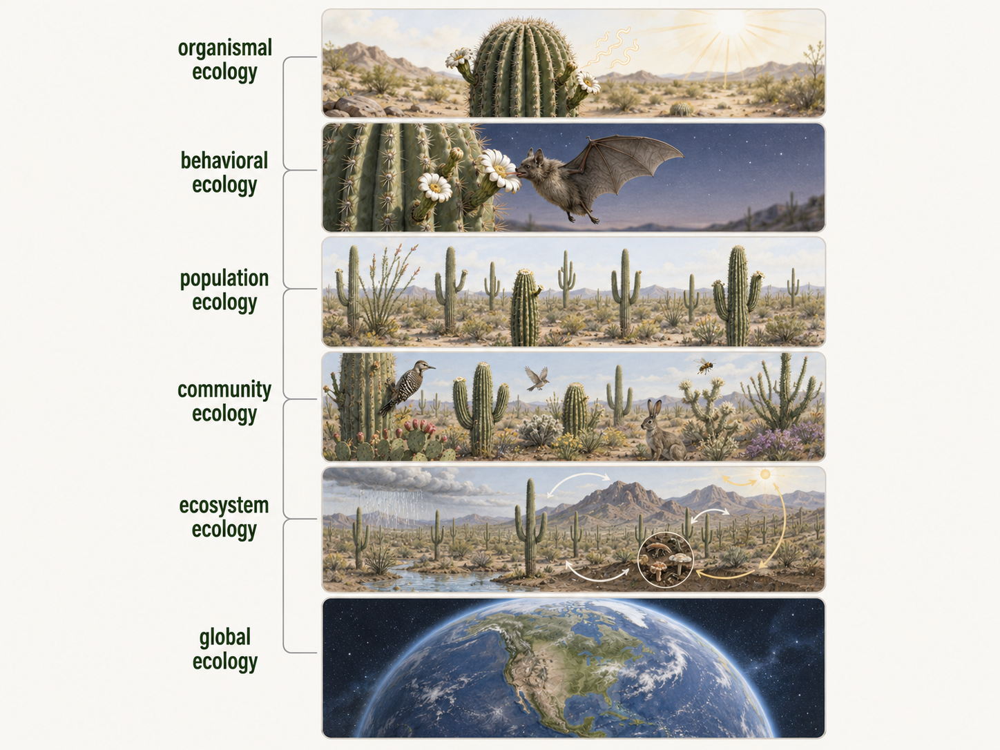
Figure 2. Fields of Ecology. Ecology can be studied at several levels of organization, from individual organisms and behavior to populations, communities, ecosystems, biomes, and the biosphere.
Organismal Ecology
Organismal ecology is the study of how individual organisms interact with their environment, focusing on the physical, physiological, and behavioral traits that allow organisms to survive and reproduce under particular conditions. For example, a desert plant may have thick waxy leaves, deep roots, or specialized photosynthesis that reduces water loss. An Arctic mammal may have thick fur, compact body shape, and fat reserves that help it survive cold temperatures. Organismal ecologists study how traits affect fitness, which means an organism’s ability to survive and reproduce in a given environment. In many ways, Charles Darwin’s work on adaptation and natural selection connects strongly to organismal ecology because he studied how traits help organisms succeed under specific environmental conditions. Organismal ecology shows that survival depends not only on where an organism lives, but also on how well its traits match that environment.
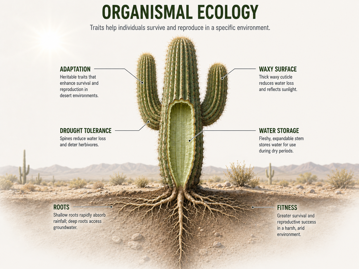
Figure 3. Organismal Ecology. Organismal ecology studies how the traits of individual organisms help them survive and reproduce in particular environments.
Behavioral Ecology
Behavioral ecology is the study of how behavior contributes to survival and reproduction. Behaviors can help organisms find food, avoid predators, choose mates, defend territories, raise offspring, migrate, communicate, or cooperate with others. A behavior has adaptive significance if it increases survival or reproductive success in a particular environment. For example, birds may migrate to follow seasonal food resources, wolves may hunt in packs to capture larger prey, and fish may school to reduce the chance that any one individual is eaten. Behavioral ecology also studies trade-offs, or behaviors that improve one part of fitness may create a cost somewhere else. For example, a male bird that sings loudly may attract mates, but it may also attract predators. Natural selection favors behaviors when their benefits outweigh their costs in a specific ecological setting.
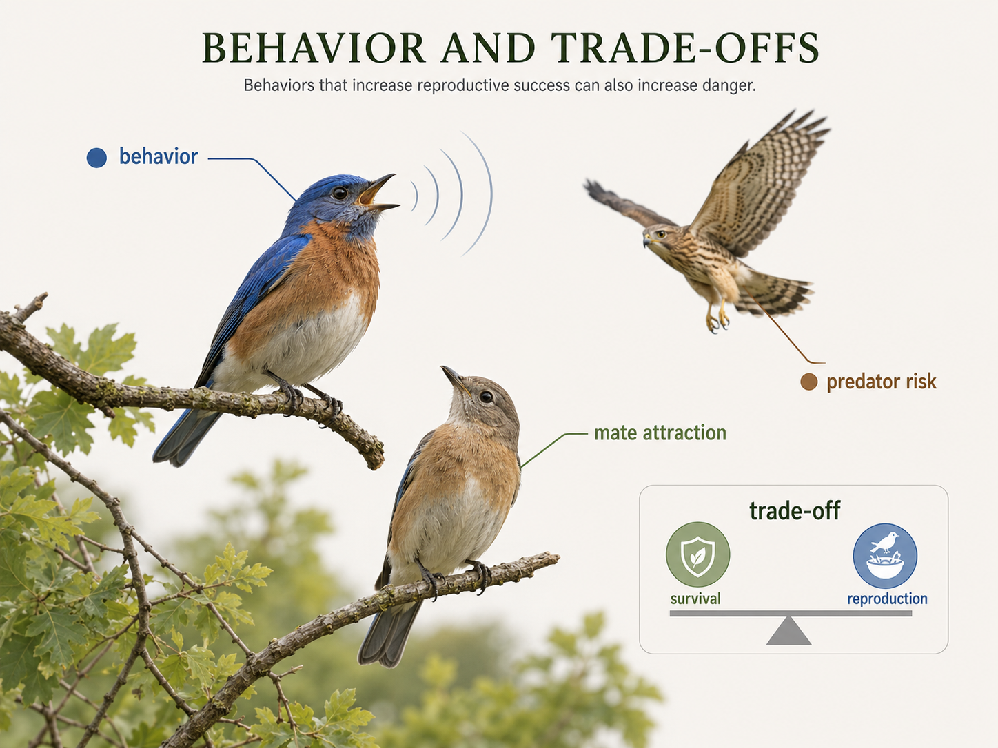
Figure 4. Behavioral Ecology. Behavioral ecology studies how behaviors affect survival and reproduction. A behavior may provide benefits, such as attracting mates, while also creating costs, such as increased predation risk
Population Ecology
Population ecology is the study of how populations change over time and space. A population is a group of individuals of the same species living in the same area at the same time. Population ecologists study population size, density, distribution, age structure, birth rates, death rates, immigration, emigration, and growth. They ask questions such as: Why is one population increasing while another is declining? What limits population growth? How does disease spread through a population? How does habitat loss affect endangered species? Population ecology often uses mathematical models because population change can be measured through births, deaths, and movement. This field is especially important for conservation biology, wildlife management, fisheries, invasive species control, and understanding human population growth.
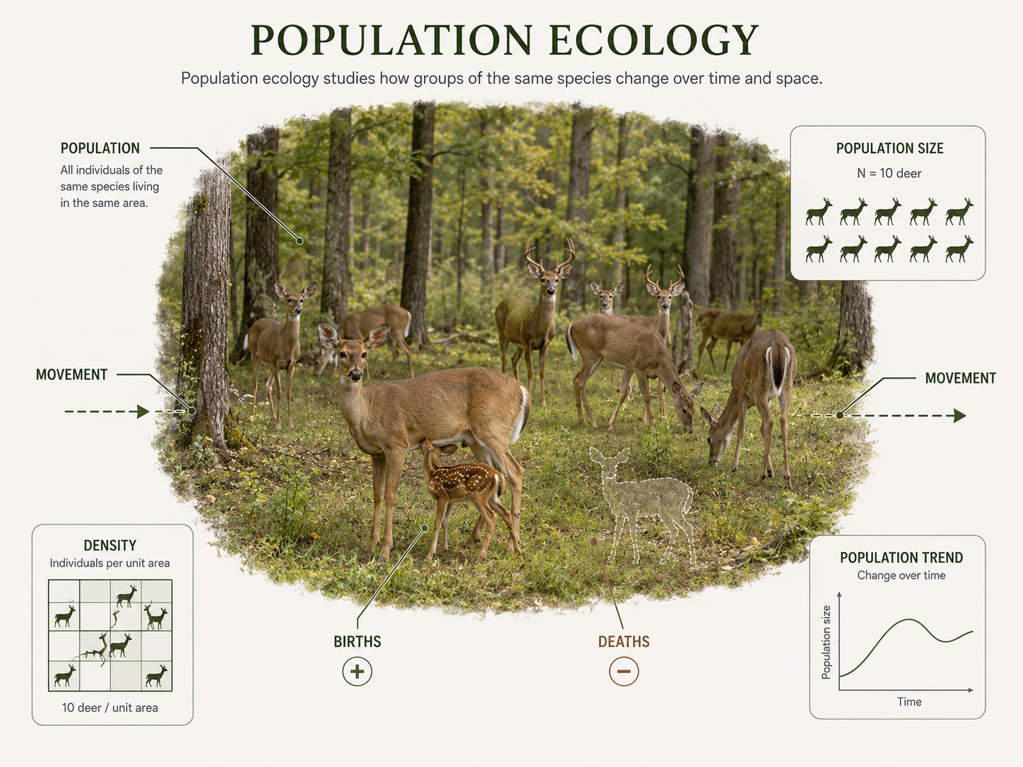
Figure 5. Population Ecology. Population ecology studies groups of individuals of the same species and how their numbers, density, distribution, and structure change over time.
Community Ecology
A community consists of populations of different species living and interacting in the same area. Community ecology studies how species interactions shape the structure and diversity of communities. These interactions include competition, predation, herbivory, parasitism, mutualism, and commensalism. For example, community ecologists may study how predators control herbivore populations, how plants compete for sunlight, how pollinators affect flowering plant reproduction, or how invasive species alter native communities. Community ecology helps explain why some species coexist while others exclude one another. It also helps scientists understand food webs, keystone species, succession, biodiversity, and the effects of disturbance. A community is not just a list of species; it is a network of interactions among species.
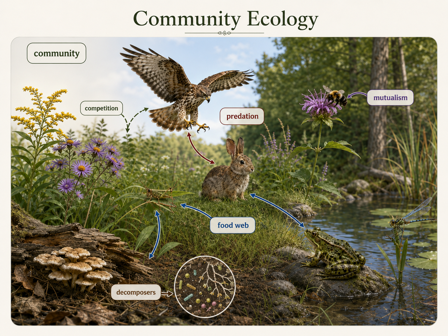
Figure 6. Community Ecology. Community ecology studies interactions among populations of different species living in the same area.
Ecosystem Ecology
Ecosystem ecology studies how living organisms interact with the physical environment through the movement of energy and matter. An ecosystem includes both the biological community and the nonliving environment around it. Ecosystem ecologists study processes such as photosynthesis, decomposition, nutrient cycling, soil formation, water movement, and energy flow through food webs. Unlike community ecology, which focuses mainly on species interactions, ecosystem ecology emphasizes the flow of energy and the cycling of elements such as carbon, nitrogen, phosphorus, and water. For example, an ecosystem ecologist might study how much carbon a forest stores, how nutrients move through a wetland, or how fire changes soil chemistry and plant regrowth. Ecosystem ecology connects biology, chemistry, geology, and climate science.
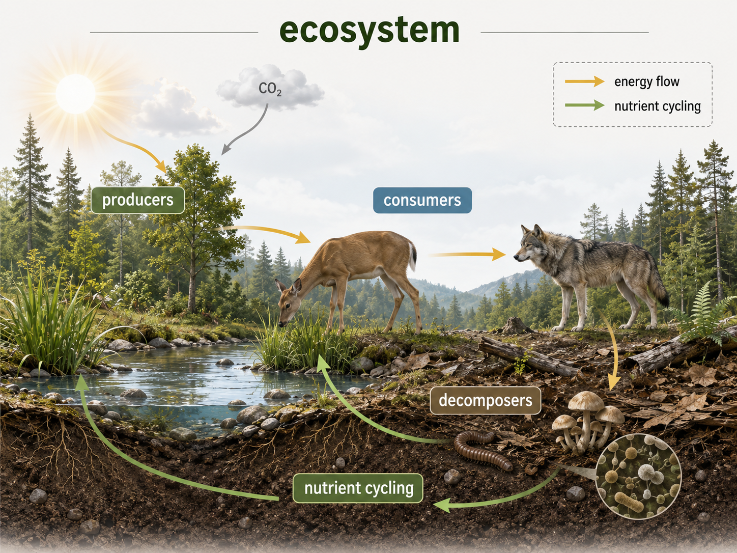
Figure 7. Ecosystem Ecology. Ecosystem ecology studies how organisms interact with the nonliving environment through energy flow and nutrient cycling.
The Biosphere
The biosphere is the global sum of all ecosystems. It includes every part of Earth where life exists, from deep ocean trenches to tropical rainforest canopies, from desert soils to polar ice edges, and from freshwater lakes to the lower atmosphere. The biosphere is shaped by sunlight, water, air, rocks, climate, and the activities of living organisms. Life also changes the biosphere. Plants and algae produce oxygen through photosynthesis, microbes cycle nutrients, decomposers return matter to the environment, and organisms influence soils, water chemistry, and atmospheric gases. The biosphere is not separate from Earth’s physical systems. It interacts with the atmosphere, hydrosphere, geosphere, and climate system. Understanding the biosphere helps explain why life is distributed unevenly across Earth and why changes in one part of the planet can affect ecosystems far away.
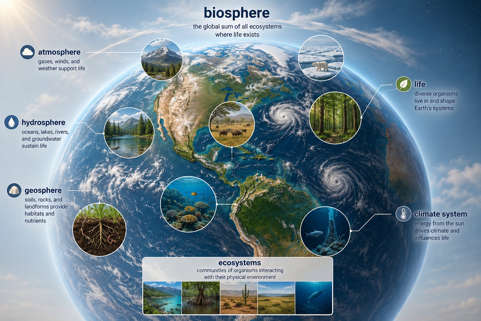
Figure 8. The Biosphere. The biosphere is the global sum of all ecosystems and includes every part of Earth where life exists.
Species Ranges
A species’ range is the geographic area where it naturally occurs. A range may be very large, covering continents or oceans, or very small, limited to one island, cave, mountaintop, lake, or forest patch. Species ranges are shaped by environmental tolerance, dispersal ability, evolutionary history, and species interactions. For example, a species may be absent from a region because the climate is too cold, the soil is unsuitable, predators are too abundant, or the species has never been able to disperse there. Humans can also alter species ranges by moving organisms intentionally or accidentally. Some species expand their ranges when climate changes, habitats are disturbed, or barriers are removed. Other species lose range as habitats are destroyed or become unsuitable. Understanding species ranges is important for conservation, invasive species biology, agriculture, disease ecology, and predicting the effects of climate change.
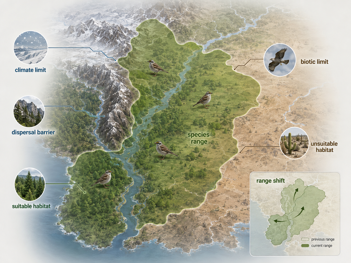
Figure 9. Species Ranges. A species’ range is the geographic area where it naturally occurs. Ranges are shaped by environmental tolerance, dispersal, evolutionary history, species interactions, and human activity.
Abiotic and Biotic Factors
The distribution of organisms is shaped by both abiotic and biotic factors. Abiotic factors are nonliving environmental conditions, such as temperature, precipitation, sunlight, wind, soil composition, water availability, salinity, pH, oxygen levels, and elevation. These factors often set the broad limits on where a species can survive. Biotic factors are living or once-living influences including: competition, predation, herbivory, parasitism, disease, mutualism, and food availability. For example, a plant may be unable to live in a desert because there is too little water, which is an abiotic limitation. Another plant may be able to tolerate the climate but fail to establish because a competitor dominates the habitat, which is a biotic limitation. Abiotic and biotic factors interact. Climate may determine where a species could live, but species interactions often determine where it actually does live.
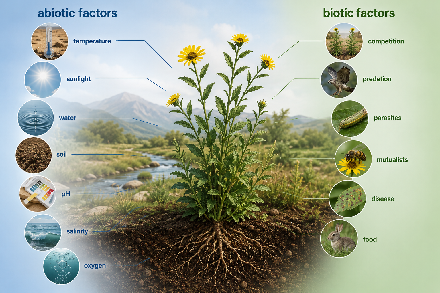
Figure 10. Abiotic and Biotic Factors. Organism distribution is shaped by nonliving conditions such as temperature and water, as well as living influences such as competition, predation, disease, and mutualism.
Tolerance and Limiting Factors
Every species has a range of environmental conditions it can tolerate. A tolerance range describes the conditions under which an organism can survive, grow, and reproduce. Conditions near the middle of the tolerance range are usually best for performance, while conditions near the edges create stress. Beyond the tolerance range, survival is impossible. A limiting factor is any factor that restricts survival, growth, reproduction, or distribution. For a desert plant, water may be the limiting factor. For an aquatic animal, oxygen concentration or water temperature may be limiting. For a forest seedling, light may be limiting. Limiting factors help explain why species are found in some places but not others. A habitat may seem suitable in many ways, but one critical factor can prevent a species from living there successfully.
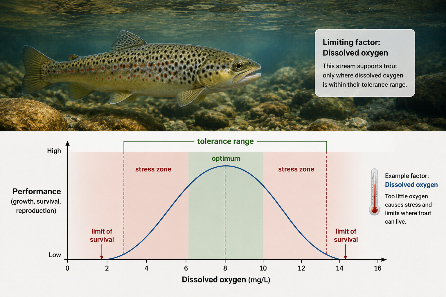
Figure 11. Tolerance and Limiting Factors. A tolerance range describes the conditions under which an organism can survive, grow, and reproduce. A limiting factor restricts survival, reproduction, or distribution
Global Climate Patterns
Earth’s major biomes are shaped primarily by patterns of temperature and precipitation, which are strongly influenced by sunlight and water availability. Temperature affects metabolism, growth, evaporation, freezing, and the length of the growing season. Precipitation affects water availability, plant growth, soil moisture, and primary productivity. Warm, wet regions generally support dense plant growth and high biodiversity, while cold or dry regions usually support lower productivity and fewer species. Climate is not the same as weather. Weather refers to short-term atmospheric conditions, such as today’s temperature, rainfall, or wind. Climate refers to long-term patterns of temperature and precipitation over many years. Biomes are shaped by climate, not by one unusual weather event. Because climate patterns vary predictably across latitude, elevation, and geography, biomes also show broad global patterns.
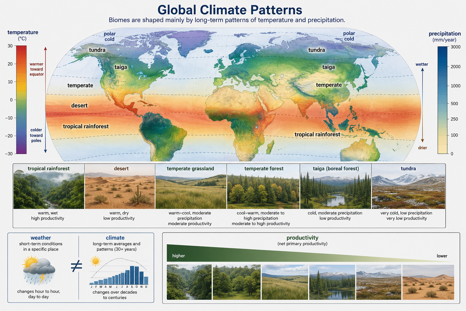
Figure 12. Global Climate Patterns. Major biomes are shaped primarily by long-term patterns of temperature and precipitation, which influence water availability, productivity, and growing season length.
Latitude and Solar Radiation
Latitude strongly affects temperature due to the nearly spherical shape of Earth. Near the equator, sunlight strikes Earth more directly, concentrating solar energy over a smaller surface area. This produces warm conditions year-round. Toward the poles, sunlight strikes at a lower angle, spreading the same amount of energy over a larger area. This reduces heating and produces colder conditions. Latitude also affects day length and seasonal variation. Equatorial regions have relatively consistent day length and warm temperatures throughout the year; whereas the poles have radically varying day lengths and temperatures throughout the year. Higher latitudes have stronger seasonal changes, including long summer days and short winter days. These differences in solar radiation help explain why tropical rainforests occur near the equator, why temperate biomes occur in middle latitudes, and why tundra and polar environments occur at high latitudes.

Figure 13. Latitude and Solar Radiation. Latitude affects climate because sunlight is more direct near the equator and more spread out near the poles.
Seasons and Earth’s Tilt
Seasons are caused by Earth’s axial tilt as it orbits the Sun. Earth’s axis is tilted about 23.5 degrees, which changes the angle and duration of sunlight received by each hemisphere during the year. When the Northern Hemisphere is tilted toward the Sun, it receives more direct sunlight and longer days, producing summer. At the same time, the Southern Hemisphere is tilted away from the Sun and experiences winter. Six months later, the pattern reverses. Seasons are not caused by Earth being closer to or farther from the Sun. They are caused by differences in solar angle and day length produced by axial tilt. Seasonal changes strongly affect ecosystems by influencing temperature, rainfall patterns, plant growth, animal migration, reproduction, dormancy, and food availability.
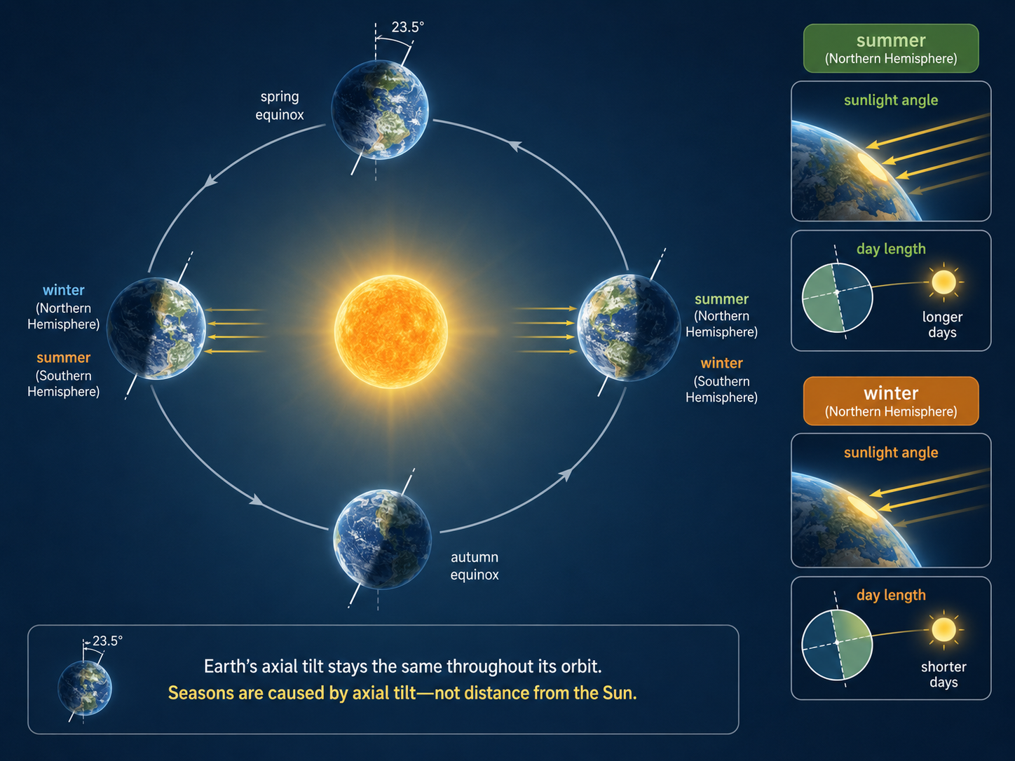
Figure 14. Seasons and Earth’s Tilt. Seasons are caused by Earth’s axial tilt, which changes the angle and duration of sunlight each hemisphere receives during the year.
Global Atmospheric Circulation
Earth’s global climate patterns are shaped by atmospheric circulation, due to unequal heating by the Sun across Earth’s surface. The equator (0°) receives more direct sunlight than the poles, so warm, moist air rises. As this air rises, it cools, water vapor condenses, and clouds and precipitation form. This helps explain why many tropical regions near the equator are warm and wet. After rising, the air moves away from the equator high in the atmosphere where it cools. The cooling air sinks around 30° north and south latitude. As this air mass sinks, it warms. However, the air mass is dry as there is no surface water to absorb, producing low-rainfall regions where many of the world’s major deserts occur. Global atmospheric circulation is organized into three major circulation cells in each hemisphere: Hadley cells, Ferrel cells, and Polar cells. Together, these cells redistribute heat and moisture around the planet and help shape global wind patterns, precipitation, temperature, and biome distribution. In general, rising air is associated with cooling, condensation, clouds, and precipitation, while sinking air is associated with warming, drying, and reduced rainfall. These patterns help explain why tropical rainforests are common near the equator, subtropical deserts often occur around 30° latitude, cool and moist temperate regions are common near 60° latitude, and polar regions are often cold and dry. Although these global patterns are modified by mountains, ocean currents, elevation, land-water differences, and seasonal winds, atmospheric circulation provides one of the main frameworks for understanding Earth’s climates and biomes.
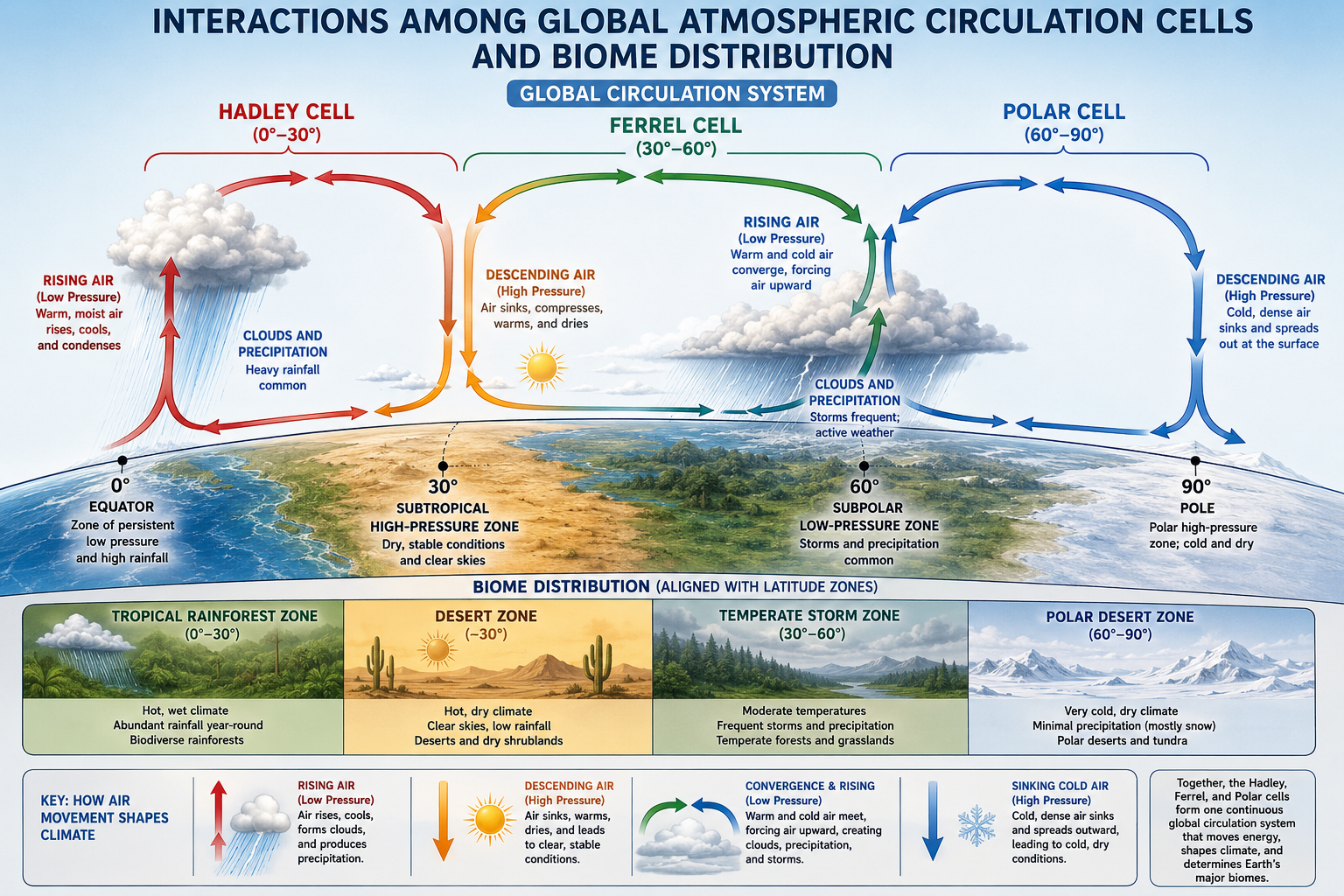
Figure 15. Overview of Global Circulation Patterns. Earth’s global atmospheric circulation is organized into Hadley, Ferrel, and Polar cells that work together to redistribute heat and moisture from the equator toward the poles. Rising air near the equator produces wet tropical conditions, while descending air near 30° creates deserts. Interactions between air masses at 60° generate stormy temperate climates, and sinking cold air at the poles produces dry polar conditions. Together, these circulation systems regulate global climate patterns, wind systems, and biome distribution across Earth.
Hadley cells
Hadley cells are tropical atmospheric circulation cells that occur between the equator and 30° north and south latitude. Intense solar heating at the equator (0° latitude) warms the air and causes it to rise. This rising air is moist because warmer air has a higher water holding capacity, meaning it can hold larger amounts of water vapor. As the air rises and cools, water vapor condenses, forming clouds and heavy rainfall. This process creates the warm, wet conditions of many tropical rainforests near the equator. After reaching higher altitudes, the air moves north and south away from the equator. Around 30° latitude, the dry air descends and warms. Descending dry air suppresses cloud formation and precipitation, contributing to major subtropical deserts such as the Sahara, Arabian, Sonoran, and Australian deserts. Near Earth’s surface, some of this air flows back toward the equator, forming trade winds that are deflected by Earth’s rotation.
Ferrel cells
Ferrel cells occur between 30° and 60° in each hemisphere. These cells are more complex than Hadley cells because they are influenced by interactions between tropical and polar air masses. Near 30° latitude, some surface air moves poleward. As this warmer air travels toward 60° latitude, it meets colder air moving away from the poles. The boundary between these air masses is often unstable and stormy. Around 60° latitude, warm air is forced upward, where it cools causing precipitation. This contributes to the relatively wet and variable climates of temperate regions, including parts of western Europe, the Pacific Northwest, eastern North America, and southern Chile. Surface winds in the Ferrel cells are deflected by the Coriolis effect, producing the prevailing westerlies, which generally move weather systems from west to east in the middle latitudes.
Polar cells
Polar cells occur between approximately 60° latitude and the poles. Near the poles (90°), sunlight strikes Earth at very low angles, producing extremely cold conditions. Cold air is dense, dry, and tends to sink, creating areas of high atmospheric pressure. This cold air moves away from the poles near Earth’s surface. Around 60° latitude, it encounters warmer air moving poleward from the Ferrel cells. The warmer air rises over the colder air, cools, and can produce clouds and precipitation. After rising, air moves back toward the poles at higher altitudes and eventually sinks again, completing the Polar cell circulation pattern. Polar regions are cold and often dry because cold air holds little water vapor. This is why polar environments can be considered deserts in terms of precipitation, even though they contain ice and snow.
The Coriolis Effect and Global Winds
The Coriolis effect is the apparent deflection of moving air and water caused by Earth’s rotation. In the Northern Hemisphere, moving air and water are deflected to the right. In the Southern Hemisphere, they are deflected to the left. The Coriolis effect helps shape global wind patterns, including trade winds, prevailing westerlies, and polar easterlies. These winds influence ocean currents, storm tracks, rainfall patterns, and climate. For example, trade winds help move warm surface water across tropical oceans, while prevailing westerlies guide many weather systems across temperate regions. The Coriolis effect does not create wind by itself; wind begins because air moves from areas of high pressure to areas of low pressure. However, Earth’s rotation changes the direction of that movement, helping organize global atmospheric circulation.
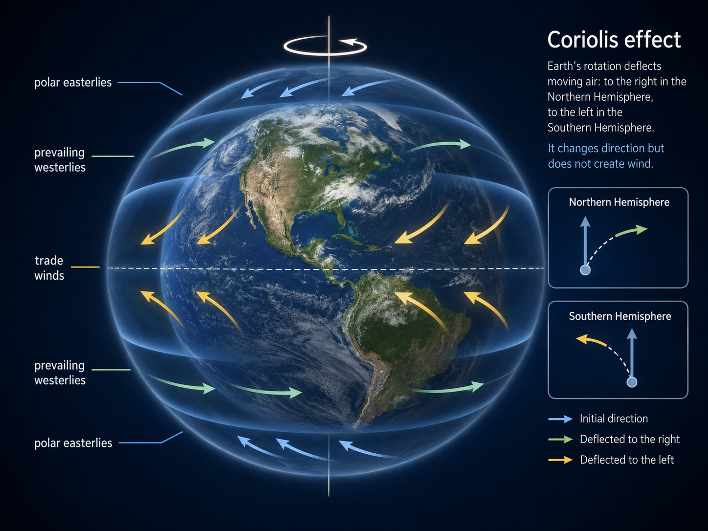
Figure 16. The Coriolis Effect and Global Winds. The Coriolis effect is the apparent deflection of moving air and water caused by Earth’s rotation. It helps shape trade winds, prevailing westerlies, and polar easterlies.
Regional Effects on Climate
Global circulation creates broad climate patterns, but local and regional geography can strongly modify temperature and precipitation. Important regional effects include mountains, elevation, ocean currents, coastlines, and distance from large bodies of water. A region at 30° latitude may be dry because of descending air, but nearby mountains can make one side wetter and the other side drier. Coastal areas may have mild climates because oceans absorb and release heat slowly. Inland areas often have more extreme seasonal temperature changes because land heats and cools faster than water. Elevation also matters because temperature generally decreases with altitude. Mountain ecosystems can therefore contain climate zones that resemble changes from low latitudes to high latitudes. These regional effects explain why local climates can differ even within the same broad latitude zone.
Rain Shadow Effect
The rain shadow effect occurs when moist air encounters a mountain range. As air rises up the windward side of a mountain, it expands and cools. Cooler air holds less water vapor, so moisture condenses into clouds and precipitation. This makes the windward side of the mountain relatively wet. After the air crosses the mountain crest, it descends on the leeward side. As it descends, it compresses, warms, and becomes drier. This creates a dry region called a rain shadow. Rain shadows help explain why deserts often occur on the leeward side of major mountain ranges. For example, the Sierra Nevada contributes to dry conditions east of the mountains, including parts of the Great Basin and Mojave Desert. Rain shadows show how topography can strongly shape local ecosystems.
Ocean Moderation Effect
Water has a high heat capacity, meaning it can absorb and store large amounts of heat with relatively small changes in temperature. Because of this, oceans moderate the climates of nearby land areas. During summer, oceans absorb heat and keep coastal areas cooler than inland areas. During winter, oceans release stored heat and keep coastal areas warmer than inland areas. As a result, coastal climates tend to have milder temperatures and smaller seasonal temperature swings than continental interiors. This is why cities near oceans often have cooler summers and warmer winters than inland cities at similar latitudes. Ocean currents also affect climate by moving warm or cold water across the planet. Warm currents can make nearby land warmer and wetter, while cold currents can cool coastal regions and sometimes contribute to dry conditions.
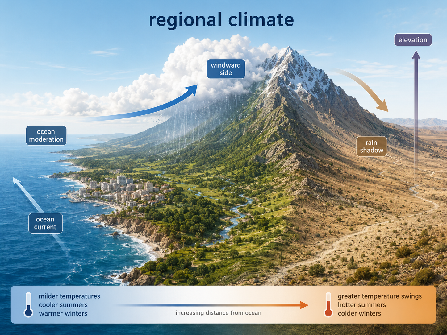
Figure 17. Regional Effects on Climate. Global circulation creates broad climate patterns, but regional geography can strongly modify local temperature and precipitation. Mountains can produce wet windward slopes and dry leeward rain shadows, while oceans moderate nearby climates by absorbing and releasing heat slowly.
Terrestrial Biomes
Terrestrial biomes are major land-based ecological regions defined mainly by climate and dominant vegetation. Temperature and precipitation strongly influence which plants can grow, and plant communities provide the physical structure and food resources that support animals, fungi, and microbes. Major terrestrial biomes include tropical rainforests, subtropical deserts, temperate grasslands, temperate forests, taiga, and tundra. Biome boundaries are not always sharp. They often grade into one another through transition zones called ecotones. For example, grassland may gradually transition into forest as precipitation increases. Biomes are useful for understanding global ecological patterns, but each biome contains many local ecosystems that vary in soil, disturbance, species composition, and human impact.
Tropical Rainforests
Tropical rainforests occur near the equator, where temperatures remain warm throughout the year and rainfall is abundant. These forests have the highest biodiversity and some of the highest biomass of any terrestrial biome. Tropical rainforests are vertically layered, with emergent trees, a dense canopy, understory plants, and a shaded forest floor. Because the canopy captures most sunlight, relatively little light reaches the ground, limiting plant growth at the forest floor. Nutrients cycle rapidly in tropical rainforests because warm, wet conditions promote fast decomposition. However, many rainforest soils are nutrient-poor because heavy rainfall can leach nutrients away. Most nutrients are stored in living biomass rather than in the soil. Tropical rainforests support enormous diversity of plants, insects, birds, mammals, fungi, and microbes, but they are also highly threatened by deforestation, fragmentation, agriculture, mining, and climate change.
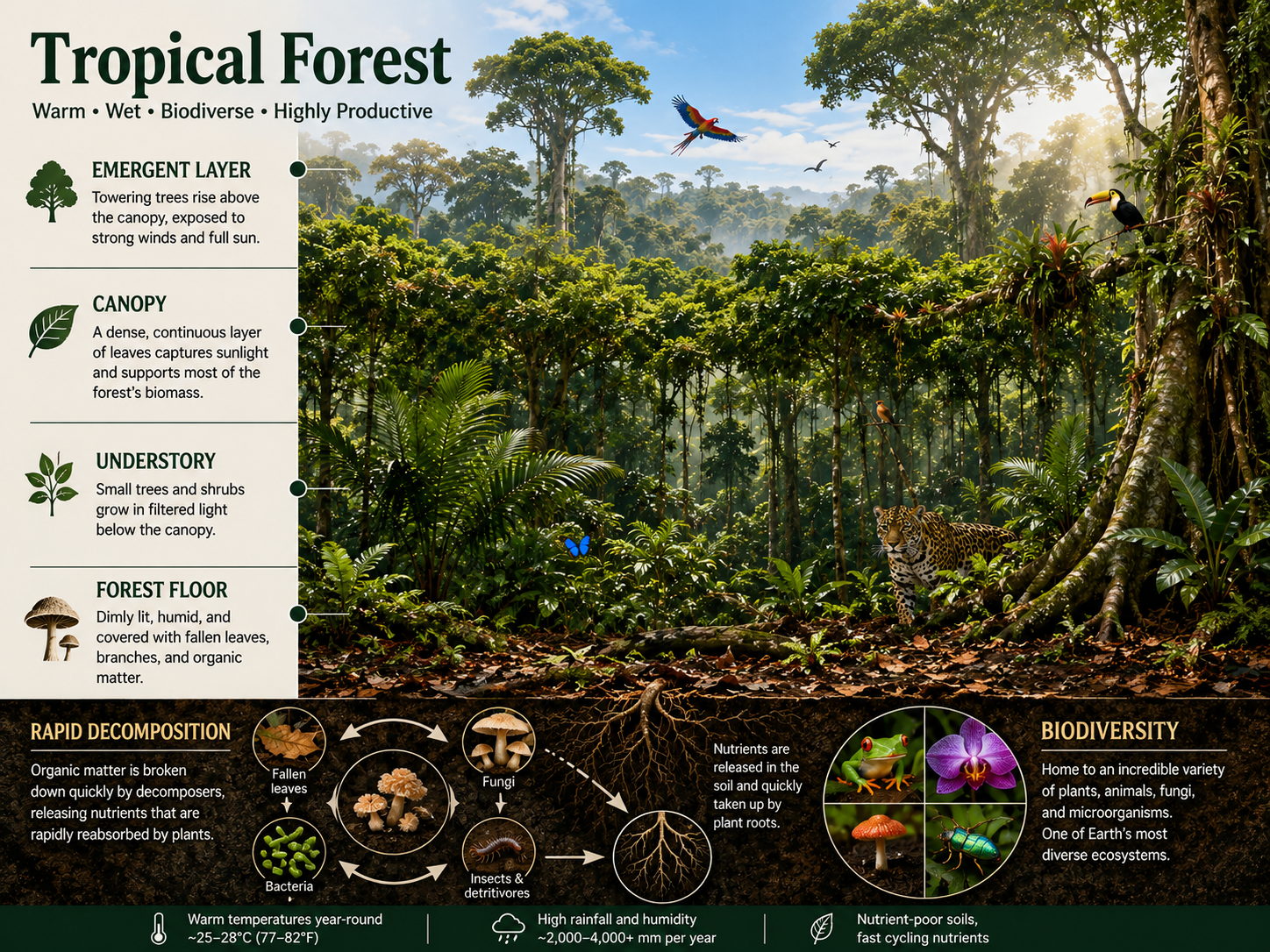
Figure 18. Tropical Rainforests. Tropical rainforests occur near the equator, where warm temperatures and abundant rainfall support high biomass, high biodiversity, vertical forest layering, and rapid nutrient cycling.
Subtropical Deserts
Subtropical deserts commonly occur near 30° north and south latitude, where descending dry air from Hadley cells reduces rainfall. Examples include the Sahara, Arabian, Sonoran, and Australian deserts. Deserts are defined by low precipitation, not necessarily by high temperature. Many subtropical deserts are hot, but some deserts can be cold. Desert ecosystems typically have sparse vegetation, low biomass, and intense competition for water. Plants are often widely spaced and may have adaptations such as deep roots, shallow spreading roots, water-storing tissues, reduced leaves, waxy coatings, or specialized photosynthesis that reduces water loss. Animals may avoid heat by being nocturnal, burrowing underground, producing concentrated urine, or obtaining water from food. Deserts may look empty at first glance, but they contain highly specialized organisms adapted to water limitation and temperature extremes.
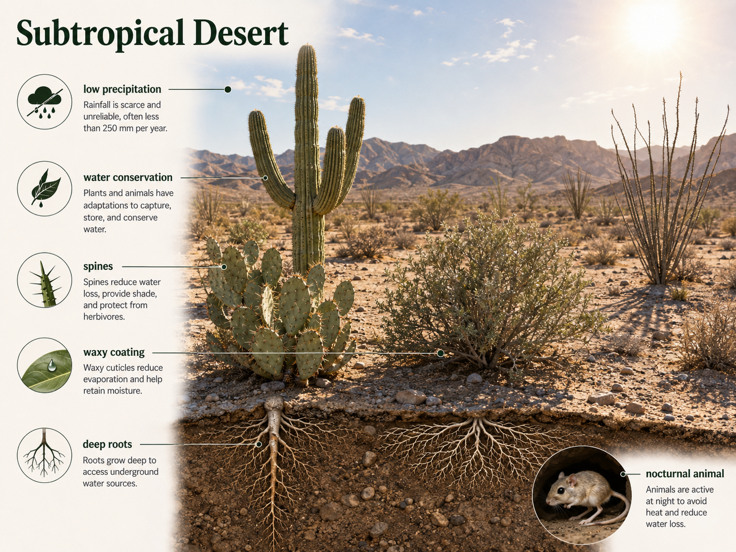
Figure 19. Subtropical Deserts. Subtropical deserts commonly occur near 30° latitude where descending dry air limits rainfall. Desert organisms are adapted to water scarcity and temperature extremes.
Temperate Grasslands
Temperate grasslands occur in regions with moderate to low precipitation, warm summers, cold winters, and frequent drought or fire. Rainfall is usually enough to support grasses but not enough to support dense forests. Grasslands are dominated by grasses and herbaceous plants, many of which grow from their bases or underground tissues. This allows them to recover after grazing or fire. Fire is a natural and important disturbance in many grasslands because it removes woody plants, recycles nutrients, and maintains open conditions. Large grazing animals also shape grassland structure by feeding on grasses and influencing plant competition. Temperate grasslands include prairies, steppes, and pampas. Many have deep, fertile soils because grass roots add organic matter over time. As a result, grasslands have been heavily converted to agriculture, making them one of the most altered terrestrial biomes.
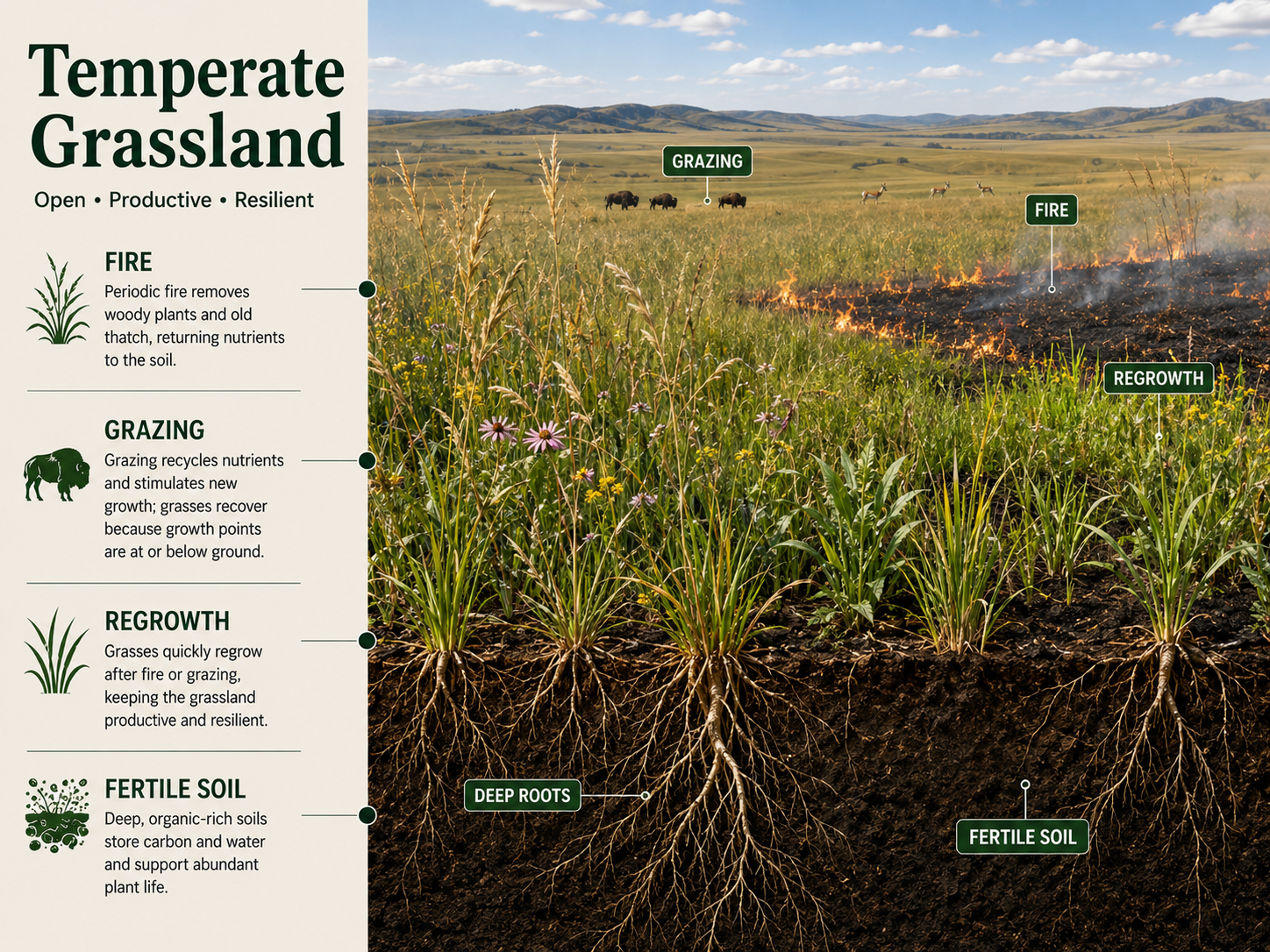
Figure 20. Temperate Grasslands. Temperate grasslands are dominated by grasses and shaped by moderate rainfall, drought, fire, grazing, and deep fertile soils.
Temperate Forests
Temperate forests occur in regions with moderate temperatures, sufficient precipitation, and distinct seasons. Many temperate forests are dominated by deciduous trees that lose their leaves during cold or dry seasons, although some temperate forests contain evergreen species. These forests often have layered vegetation, including canopy trees, understory trees, shrubs, herbs, mosses, fungi, and leaf litter communities. Decomposition is slower than in tropical rainforests because winters are cooler, so nutrients may accumulate in soils and leaf litter. Temperate forests support moderate to high biodiversity, including insects, birds, mammals, amphibians, fungi, and soil organisms. Seasonal changes strongly shape life in temperate forests. Many plants flower in spring before the canopy fully closes, animals may migrate or hibernate, and trees enter dormancy during winter.
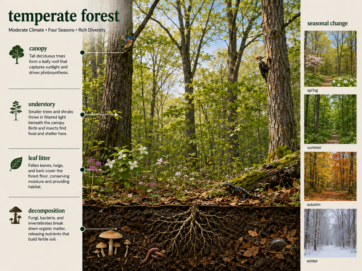
Figure 21. Temperate Forests. Temperate forests occur in regions with moderate temperatures, sufficient precipitation, and distinct seasons. They often have layered vegetation, leaf litter, fungi, and seasonal cycles of growth and dormancy.
Taiga
The taiga, also called the boreal forest, is a cold forest biome found across northern North America, Europe, and Asia. It lies south of the tundra and north of many temperate forests. The taiga has long, cold winters and short, cool summers. Precipitation is moderate to low, but evaporation is also low because temperatures are cold. The taiga is dominated by coniferous trees such as spruce, fir, pine, and larch. These trees often have needle-like leaves, waxy coatings, and conical shapes that help them tolerate cold, snow, and short growing seasons. Biodiversity is lower than in temperate or tropical forests because fewer species can tolerate the harsh climate. Productivity is also relatively low because cold temperatures slow photosynthesis and decomposition. The taiga stores large amounts of carbon in trees, soils, and peatlands, making it important in the global carbon cycle.
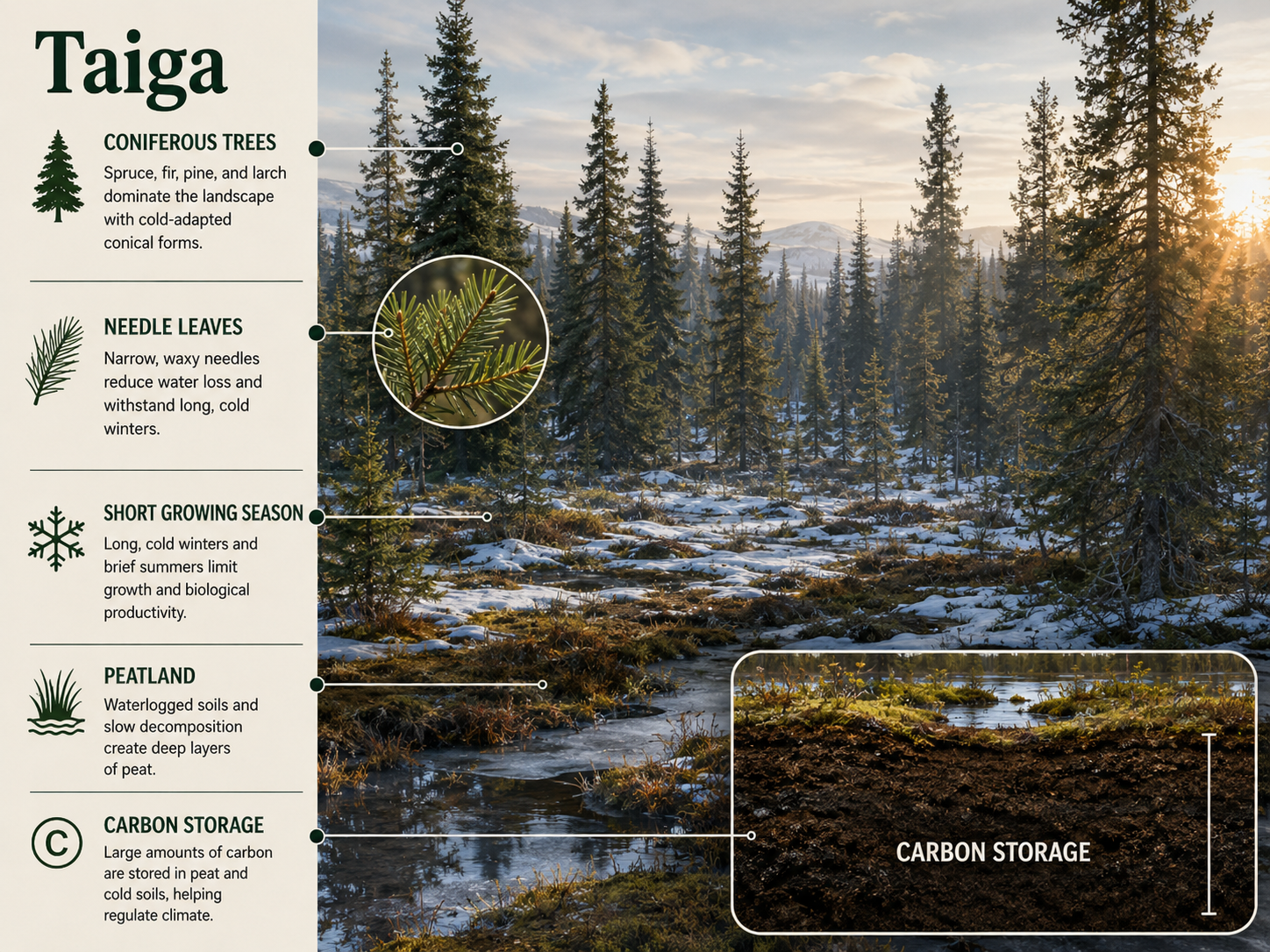
Figure 22. Taiga. The taiga, or boreal forest, is a cold conifer-dominated biome with long winters, short summers, low productivity, and large carbon stores in trees, soils, and peatlands.
Tundra
Tundra occurs in Arctic regions and high mountain environments where temperatures are very cold and the growing season is extremely short. Arctic tundra has permafrost, which is permanently frozen ground beneath the surface. During summer, only the upper layer of soil thaws, creating wet, shallow soils because water cannot drain easily through the frozen layer below. Tundra vegetation is low-growing and includes mosses, lichens, grasses, sedges, and small shrubs. Trees are mostly absent because roots cannot grow deeply, temperatures are too cold, and the growing season is too short. Animals such as caribou, musk oxen, Arctic foxes, migratory birds, insects, and small mammals are adapted to seasonal extremes. Tundra ecosystems are especially vulnerable to climate warming because thawing permafrost can change hydrology, release stored carbon, and allow shrubs to expand into formerly open tundra.
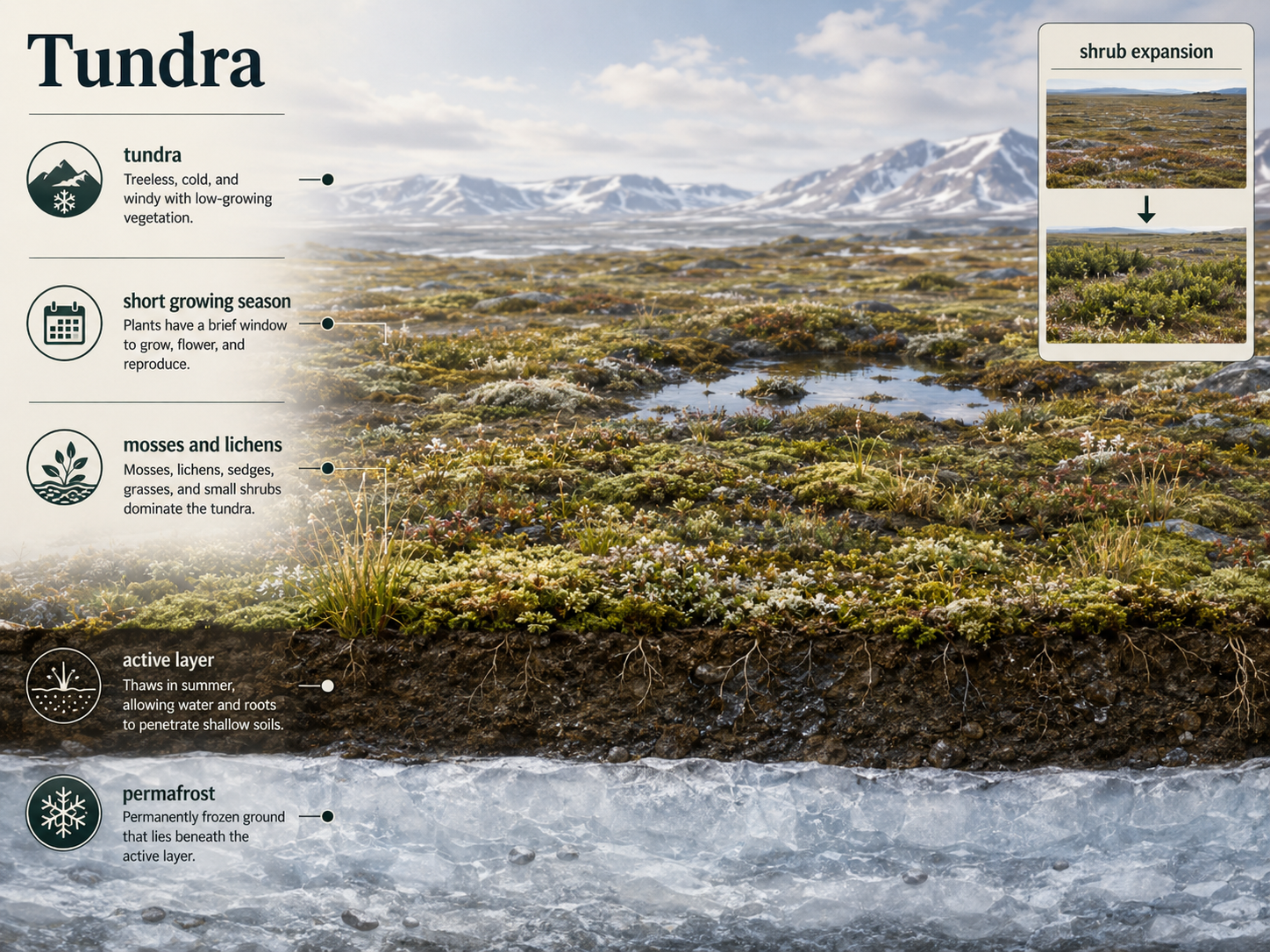
Figure 23. Tundra. Tundra occurs in Arctic and alpine environments with very cold temperatures, short growing seasons, permafrost, and low-growing vegetation.
Aquatic Biomes
Aquatic biomes are water-based ecosystems shaped by factors such as salinity, depth, light availability, temperature, oxygen, nutrients, water movement, and substrate. They are often divided into freshwater, estuarine, and marine ecosystems. Freshwater ecosystems include lakes, ponds, rivers, streams, and wetlands. Marine ecosystems include intertidal zones, coral reefs, open ocean, and benthic environments. Estuaries occur where freshwater and seawater mix. Aquatic ecosystems differ from terrestrial ecosystems because light and oxygen can decline sharply with depth, water movement can transport organisms and nutrients, and salinity creates major physiological challenges. Aquatic ecosystems are essential for biodiversity, nutrient cycling, water purification, food production, climate regulation, and human societies.
Lakes and Ponds
Lakes and ponds are standing bodies of freshwater. They vary greatly in size, depth, temperature, nutrient levels, oxygen availability, and biological productivity. The littoral zone is the shallow nearshore area where sunlight reaches the bottom and rooted aquatic plants can grow. The limnetic zone is the open-water region that receives enough light for photosynthesis. Together, the sunlit areas are part of the photic zone, where photosynthesis can occur. The profundal zone is deeper water below the photic zone in larger lakes, where little or no sunlight penetrates. The benthic zone consists of the bottom sediments, where decomposers and detritivores feed on dead organic matter that sinks from above. Lakes and ponds often show temperature and oxygen layering, especially in deeper systems. These layers can mix seasonally, redistributing oxygen and nutrients.
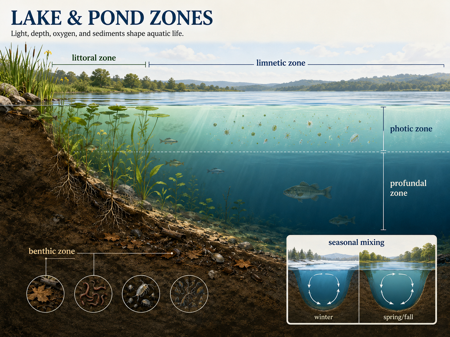
Figure 24. Lakes and Ponds. Lakes and ponds are standing freshwater ecosystems with zones shaped by depth, light availability, oxygen, nutrients, and sediments.
Freshwater Wetlands
Freshwater wetlands are shallow ecosystems where soils are saturated with water for long periods. They are among the most productive ecosystems on Earth and provide important habitat for birds, amphibians, fish, insects, plants, and microbes. Wetlands are dominated by emergent vegetation, meaning plants that are rooted in water-saturated soil but rise above the water surface. Major types of freshwater wetlands include marshes, swamps, and bogs. Marshes are dominated by nonwoody plants such as grasses, sedges, and reeds. Swamps are dominated by woody plants such as trees and shrubs, including cypress swamps in Florida. Bogs are acidic, nutrient-poor wetlands often dominated by sphagnum moss. Wetlands filter pollutants, reduce flooding, store carbon, recharge groundwater, and provide breeding habitat for many species.
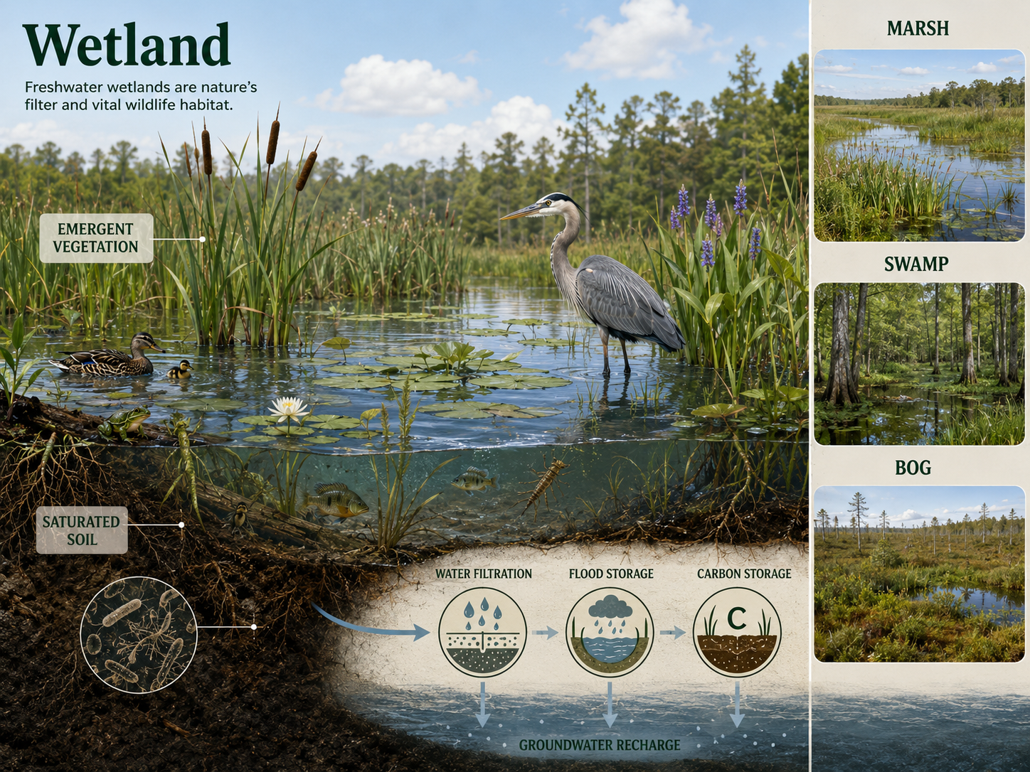
Figure 25. Freshwater Wetlands. Freshwater wetlands are shallow saturated ecosystems with high productivity, emergent vegetation, important wildlife habitat, water filtration, flood reduction, and carbon storage.
Streams and Rivers
Streams and rivers are flowing freshwater ecosystems in which water moves continuously in one direction. Near their sources, streams are often cold, narrow, fast-moving, and high in oxygen. These headwater areas may have fewer plants because shading and fast currents limit photosynthesis, so many organisms depend on leaves and organic matter from surrounding land. As streams flow downstream, they usually become wider, warmer, slower, and more nutrient-rich. More sunlight reaches the water, allowing more algae and aquatic plants to grow. Biodiversity often increases downstream as habitats become more varied. Rivers connect landscapes by moving water, sediments, nutrients, organisms, and organic matter from land to lakes, wetlands, estuaries, and oceans. Human activities such as dams, pollution, water withdrawal, and channelization can strongly alter river ecosystems.
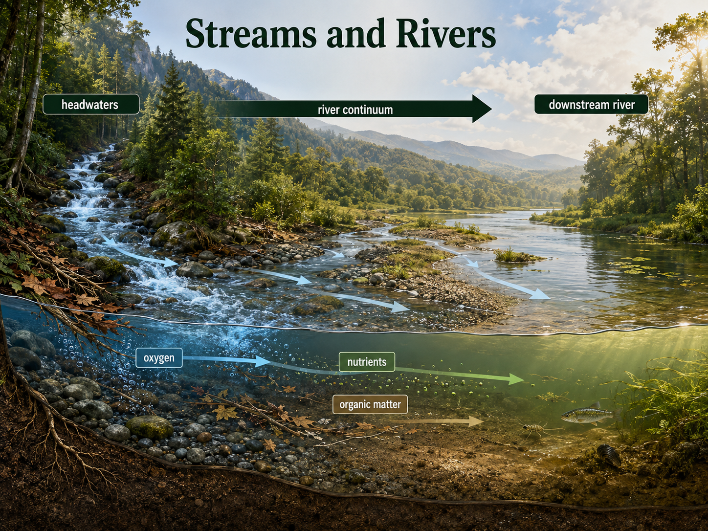
Figure 26. Streams and Rivers. Streams and rivers are flowing freshwater ecosystems that change from cold, fast, oxygen-rich headwaters to wider, warmer, more nutrient-rich downstream reaches.
Estuaries
Estuaries occur where rivers meet the ocean and freshwater mixes with saltwater. This mixture creates brackish water, with salinity levels that change over time. Salinity in estuaries depends on tides, freshwater input, rainfall, drought, evaporation, and distance from the ocean. During droughts, salinity may increase because less freshwater enters the estuary. During heavy rainfall, salinity may decrease because freshwater dilutes seawater. Estuaries are highly productive because rivers bring nutrients from land while tides circulate water and organisms. They often support salt marshes, mangroves, seagrass beds, oyster reefs, fish nurseries, birds, crabs, shrimp, and many invertebrates. Estuaries also protect coastlines by absorbing storm energy and trapping sediments. Because they occur where rivers, oceans, and human settlements meet, estuaries are vulnerable to pollution, dredging, development, sea-level rise, and nutrient runoff.
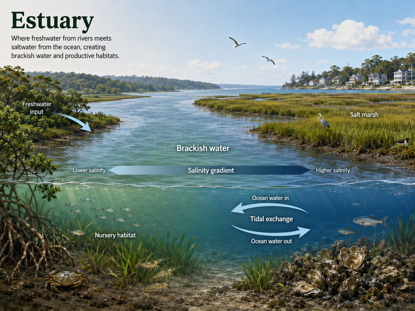
Figure 27. Estuaries. Estuaries form where rivers meet the ocean and freshwater mixes with saltwater, creating productive brackish habitats with changing salinity.
Marine Aquatic Biomes
Marine biomes are saltwater ecosystems that cover most of Earth’s surface. They are shaped by depth, light availability, temperature, salinity, currents, pressure, nutrients, and distance from shore. Marine ecosystems include intertidal zones, coral reefs, the open ocean, deep sea, and benthic habitats. The ocean plays a central role in Earth’s climate because it stores and moves heat, absorbs carbon dioxide, produces oxygen through marine photosynthesis, and supports global food webs. Marine primary production is largely driven by microscopic phytoplankton in sunlit waters. However, nutrients are often limited near the surface, especially in the open ocean. Upwelling, currents, and mixing can bring nutrients from deep water to the surface, supporting high productivity in some regions. Marine ecosystems are affected by overfishing, warming, acidification, pollution, habitat damage, and oxygen decline.
Intertidal Zones
The intertidal zone is the marine shoreline area between high tide and low tide. Organisms living there are alternately submerged underwater and exposed to air. This makes the intertidal zone physically stressful. Organisms must tolerate waves, drying, temperature changes, changing salinity, sunlight exposure, and predation. Rocky intertidal zones often contain barnacles, mussels, sea stars, crabs, snails, algae, and sea anemones. Sandy intertidal zones often contain burrowing organisms such as clams, worms, and small crustaceans. Many intertidal organisms have adaptations that help them attach tightly, close their shells, retain moisture, or burrow into sediment. Intertidal communities are also shaped by competition and predation. Because organisms live in visible bands along the shore, intertidal zones have been important model systems for studying community ecology.
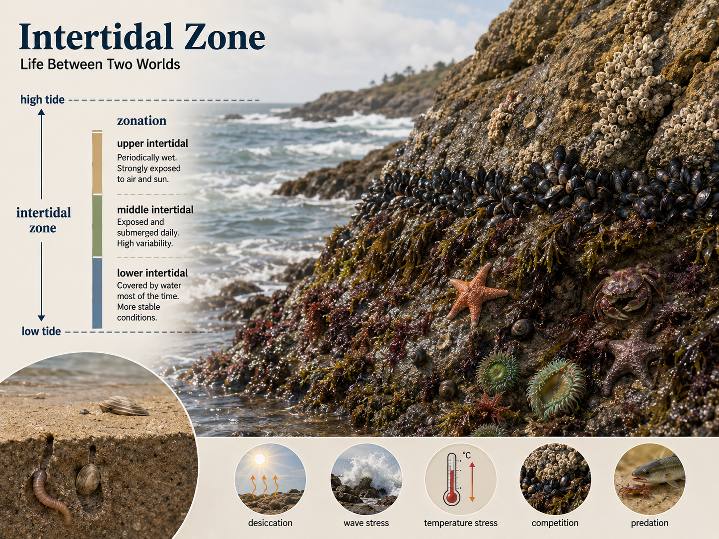
Figure 28. Intertidal Zones. The intertidal zone lies between high tide and low tide. Organisms there must tolerate waves, drying, temperature change, salinity change, sunlight exposure, competition, and predation.
Coral Reefs
Coral reefs are marine ecosystems built by coral animals that secrete calcium carbonate skeletons. Reef-building corals are most common in warm, shallow, clear tropical waters because they depend on photosynthetic symbionts living inside their tissues. These symbionts provide sugars produced by photosynthesis, while the coral provides protection, carbon dioxide, and nutrients. Coral reefs support extremely high biodiversity, including fish, crustaceans, mollusks, worms, sponges, algae, and many other organisms. They also protect coastlines and support fisheries and tourism. When corals are stressed by high temperature, pollution, sedimentation, or other factors, they may expel their symbiotic algae. This causes coral bleaching, where corals turn pale or white. Bleached corals are not immediately dead, but they are weakened and may die if stressful conditions continue.
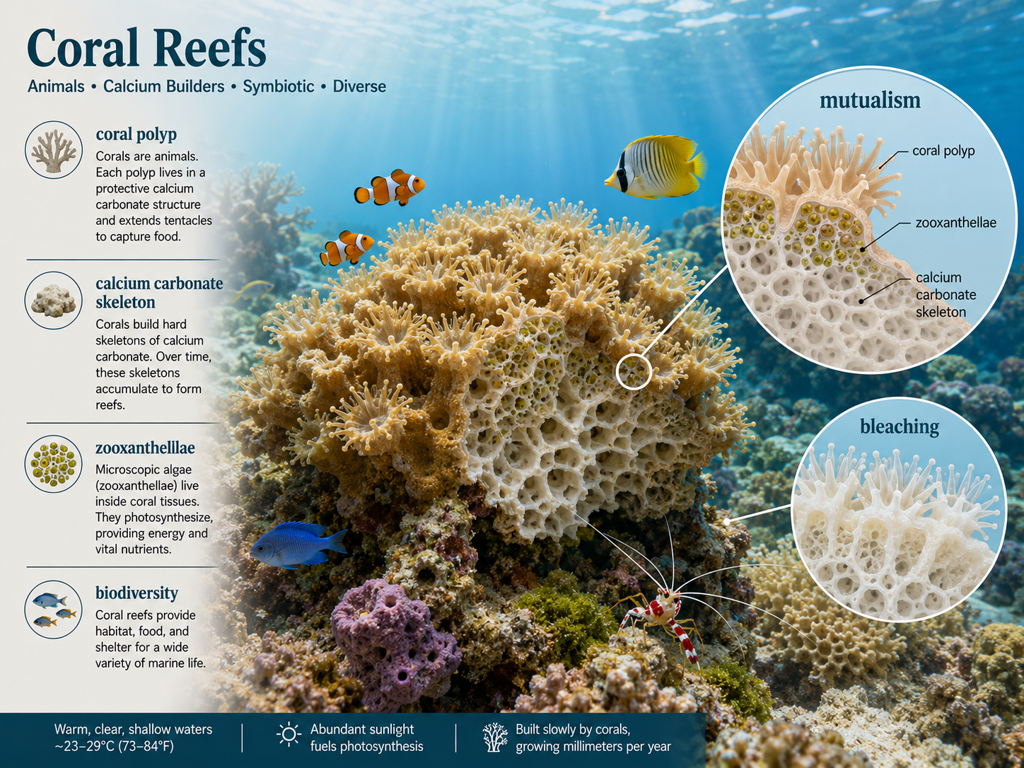
Figure 29. Coral Reefs. Coral reefs are built by coral animals that secrete calcium carbonate skeletons and often depend on photosynthetic dinoflagellate symbionts.
Pelagic Zone
The pelagic zone is the open-water region of the ocean away from the shore and above the ocean floor. The upper pelagic zone contains the photic zone, where enough sunlight penetrates for photosynthesis. This zone supports phytoplankton, zooplankton, fish, squid, sea turtles, marine mammals, and many other organisms. Large organisms that swim actively through the water are called nekton. Examples include sharks, tuna, dolphins, whales, squid, and sea turtles. Small drifting organisms are called plankton. Phytoplankton are photosynthetic plankton, while zooplankton are animal-like plankton that feed on phytoplankton or other small organisms. Below the photic zone, the ocean becomes darker, colder, and higher in pressure. Many deep pelagic organisms depend on organic matter sinking from above, while others migrate vertically each day to feed near the surface at night.
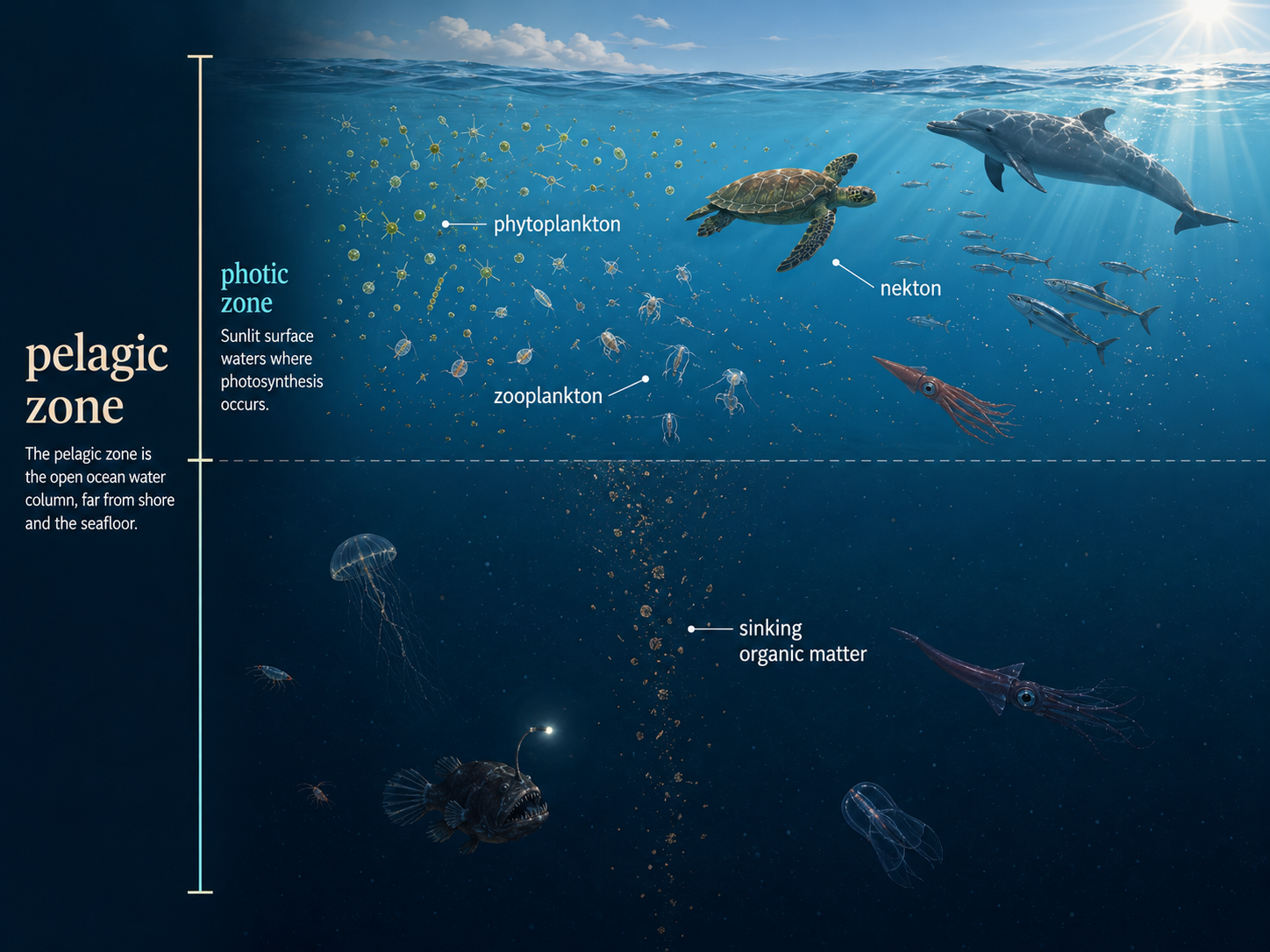
Figure 40. Benthic Zone. The benthic zone is the bottom region of aquatic ecosystems. Benthic organisms contribute to decomposition, nutrient recycling, sediment formation, and habitat structure.
Benthic Zone
The benthic zone is the bottom region of oceans, lakes, rivers, and other aquatic systems. Organisms living on or in the bottom are called benthos. In marine ecosystems, benthic organisms include sea stars, crabs, clams, worms, sponges, corals, bacteria, and many burrowing animals. In deep ocean environments, the benthic zone is dark, cold, and under high pressure. Many benthic organisms feed on detritus, which is dead organic material that sinks from upper water layers. Others filter food from the water, graze on algae, prey on other benthic organisms, or rely on chemosynthetic bacteria near hydrothermal vents. The benthic zone is important because it is where much decomposition, nutrient recycling, sediment formation, and habitat creation occur. Even though deep benthic environments may seem remote, they are connected to surface ecosystems through the sinking of organic matter.
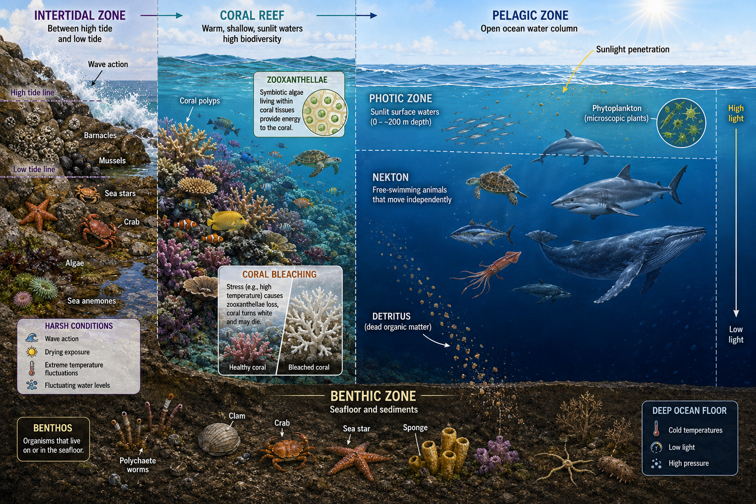
Figure 30. Benthic Zone. The benthic zone is the bottom region of aquatic ecosystems. Benthic organisms contribute to decomposition, nutrient recycling, sediment formation, and habitat structure.